

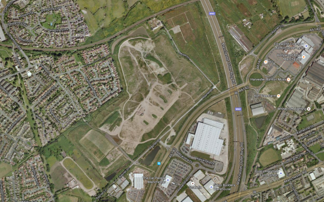

To the east of Manchester and the west of Ashton sits The Moss.
This area of low lying, deep peaty bog, just outside Ashton-under Lyne, was drained in the mid 1800’s to grow some of the best crops – It was world famous for its celery but also grew good cabbage, cauliflowers and lettuce, with cucumbers and tomatoes grown in glasshouses.
This map of 1861 shows an area criss-crossed with lanes, ditches and field boundaries.
A world that survived into the 1980s, captured here so beautifully by Brian Lomas, prior to the building of the M60.


Photographs from – Tameside Image Archive
Then came the railways:


With an attendant ghost:

And telecommunications installation

Its location on the south east corner of the Lancashire Coalfield, and the burgeoning demands of the Industrial Revolution saw the further development of mining in the area.
As the demand for coal outstripped the output, a deeper mine was opened in 1875, at Ashton Moss. This new pit had its own railway branch and canal arm for efficient transportation of the coal. In 1882 a second shaft was sunk – at 2,850 feet, the deepest in the world at that time.
The New Rocher pit closed in 1887 and Broadoak pit closed in 1904, after which time Ashton Moss pit was the only coal mine still in operation in Ashton. Although it produced 150,000 tons of coal a year in the early 1950s and employed over 500 men, Ashton Moss colliery closed in 1959 and part of its site is now the Snipe Retail Park on the boundary with Audenshaw.
Seen here in this painting by local artist David Vaughan.

Colliery lamp token.


This tight little island of land was a contrasting mix of the agricultural and industrial, home also to the urgent demands of a leisured and growing working class.
The area boasted two motorcycle speedway tracks.
One located on the Audenshaw side, just behind The Snipe pub.

And one in Droylsden at the Moorside Stadium – home to local legend Riskit Riley:


The stadium later to become a horse trotting track, known locally as Doddy’s Trot
The Moss has also provided a home for Curzon Ashton football club

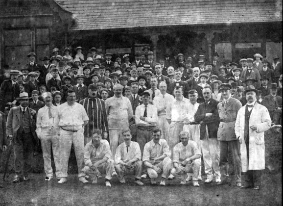
And Ashton Cricket and Bowling Club.
The cricket and the football have both survived the building of the Orbital Ring Road, and the development of the site as a light industrial, retail and leisure park.
The roar of Riskit Riley is heard no more.

What a great article. Interesting and very comprehensive.
The old map that is often said to be 1848 is in fact 1861 because of the Guide Bridge, Ashton and Oldham railway line. There is a map from 1861. I have is somewhere.
LikeLike
I lived in this area in the 1950s and early 60s, when the coal mine was still operating. There were certainly slag heaps: brave kids rode their bikes down them. I went to the pit to get material for a primary school project on coal (Aldwyn primary school) and remember getting a gold star. Thanks so much for this entry.
LikeLike
Y’welcome Sue I remember the slag heaps too.
LikeLike
Thanks Ian – I will amend the date, glad you enjoyed the article.
LikeLike
I vaguely remember the slag pile from Ashtom Moss colliery in the early 80’s. Don’t think I’m mistaken.
LikeLike
There surely was a huge slag heap – on the site of the now Snipe Retail Park Jonathan
LikeLike
I used to ride from stables on Ashton Moss
LikeLike
my father worked there for years and was involved in a roof fall he was then transfered to the bradford pit where the manchester city football ground is now
LikeLike
In the late 50’s early 60’s I used to live on Milton Rd at the back of the Snipe pub and remember the slag heap opposite the pub. There was a small garage for fuel and repairs in front of the heap. I also used to walk to Droylesden past the primary school and the land was alight below ground so you had to carefully follow the paths.
LikeLike
My dad was Frank Mooring the shoe repairer at the Snipe next to the old railway bridge and long-closed Audenshaw station. Sam Kelly the builder used to be opposite [His house was a big detached one]. It backed onto the pit hills [slag heaps] which covered land from Slate Lane and Groby Road almost to Manchester Road. On the same side of the road going towards Ashton there was a small ‘sales’ area containing a few sheds and greenhouses. then a couple of large advertising hoardings at right angles to the road. Next to that was the transport cafe where hauliers grabbed a bite to eat pre-M62. Across the unmade road next to it was the petrol station opposite the Snipe Inn. The colliery entrance was next just beyond the miners baths. All from memory as I spent many of my early years walking on the Moss, ‘fishing’ in the Snipe pond, playing along the canal and biking on the pit hills. Happy Days!
LikeLike
Thanks for that Paul – happy days indeed!
LikeLike
Thanks, Paul. I certainly remember the builder’s, and I’m 95% sure that your Dad’s place was where we got our shoes repaired. When I close my eyes I can almost picture it …
LikeLike
I’m sure snipe pit closed in the 60s definitely not 50s I was grown up when my dad was made redundant n I was born in 51
LikeLike
I’ll double check Kathleen – thanks for the tip.
LikeLike
Ashton Moss colliery closed in 1959 http://www.ashton-under-lyne.com/history/coal.htm
LikeLike
I lived in audenshaw and visited the people who lived at the mine. I went to school with the daughter
LikeLike